Connect with us

National

Binga villagers panic as gigantic Shangani-Gwayi Dam nears completion  

Published

on

BY NOKUTHABA DLAMINI

Hundreds of villagers from Binga’s Lubimbi area say they are facing an uncertain future as the government is keeping them in the dark about the construction of the Gwayi-Shangani Dam, which will displace them.

Advertisement

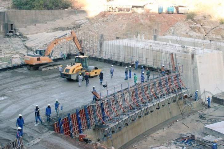
The gigantic dam being constructed on the confluence of two major rivers in Matabeleland North – Gwayi and Shangani – will have a holding capacity of 650 million cubic metres of water.

It is a central component of the long-awaited Zambezi Water Project that is touted as a permanent solution to Bulawayo’s perennial water shortages and the Chinese contractor says the dam will be completed by end of this year.

Lubimbi villagers, who are estimated to be over 2 500, say even though the dam is nearing competition the government has not shared any information about their imminent relocation or progress on the construction of the dam despite its far-reaching impact on their future.

Advertisement

The panicking villagers have since written to the Binga rural district council chief executive officer Joshua Muzamba demanding answers about their proposed relocation and the fate of infrastructure around the Lubimbi area that would be affected by the dam.

In the letter by their lawyer Jabulani Mhlanga from the Zimbabwe Lawyers for Human Rights, the Lubimbi villagers they only became aware of the construction of the dam in December 2019 through the grapevine.

The villagers say the have since then been seeking information about the dam and their relocation from relevant government departments without any success.

Advertisement

“According to our clients, Chiboni and Magani villages with at least 500 to 600 households and a population of more than 2 500 people and 2 000 herd of cattle are likely to be relocated,” reads part of the letter by Mhlanga.

“About 1 506 hectares of land, Lubimbi Number2 Primary School with a yearly enrolment of about 300 students, community projects such as cattle pens, a dip tank (and) 16 boreholes just to mention a few will be lost.”

The letter added: “Access to the local clinic and Lubimbi High School will be a challenge.

Advertisement

“All these services are critical to the wellbeing of the Lubimbi community.

“Further, cultural sites, being the burial sites and a rain making shrine, which is important to the Tonga community in Lubimbi will also be lost.

“We state all these to highlight the grave concerns our clients have.”

Advertisement

The community argued that they are being forced to rely on the media when seeking information about the construction of the dam.

They demanded a response within seven days.

The letter was also copied to the provincial environment manager and the district coordinator.

Advertisement

The government has remained mum about the relocation of people that would be displaced by the dam whose construction began during the Robert Mugabe era.

Advertisement
Continue Reading
Click to comment

Leave a Reply

Your email address will not be published. Required fields are marked *

National

Flooding risk rises in Zimbabwe, Southern Africa as heavy rains forecast

Published

on

Flooding is expected to intensify across parts of Southern Africa, including Zimbabwe, as heavy rainfall continues to affect the region, according to the latest weather hazards update from the Famine Early Warning Systems Network (FEWS NET).

In its Global Weather Hazards Summary for March 12–18, FEWS NET said moderate to locally heavy rainfall has been observed across several countries in the region, raising concerns about flooding in vulnerable areas.

Advertisement

The agency said the rainfall has affected western, central and eastern parts of Southern Africa, including Angola, Zambia, Malawi, central Mozambique, northern Madagascar, Botswana, Namibia, South Africa and Zimbabwe.

“During the past week, moderate to locally heavy rainfall was observed over northern, central and eastern Southern Africa,” FEWS NET said in the report.

The agency noted that flooding has already been recorded in some parts of the region, including Cunene Province in southern Angola and Rundu in northern Namibia, as rainfall continued across several countries.

Advertisement

Over the past 30 days, cumulative rainfall has been above average across southeastern Angola, northeastern Botswana, central South Africa, Lesotho, central and southern Zimbabwe and parts of Malawi and Mozambique, increasing the likelihood of flooding in low-lying and flood-prone areas.

FEWS NET warned that the situation could worsen in the coming days.

“(This week) , heavy rainfall is predicted over northern and eastern Zambia, including central and northern Angola, central and eastern Zambia, Malawi, northern and eastern Zimbabwe, Mozambique, northeastern South Africa, Eswatini and northern Madagascar,” the report said.

Advertisement

According to the outlook, the forecast rainfall raises the risk of flooding in many local areas across the region, particularly where soils are already saturated following weeks of above-average rainfall.

The weather monitoring agency also noted that hot conditions are likely in western Angola and southwestern Madagascar, even as other areas brace for continued heavy rains.

FEWS NET provides climate and food security early warning information to support humanitarian planning and disaster preparedness across vulnerable regions.

Advertisement

Continue Reading

National

Parliament debates disputed chiefdoms across the country

Published

on


BY STAFF REPORTER 

Advertisement

Parliament has raised concern over increasing disputes over traditional leadership, with lawmakers warning that contested chiefdoms are undermining governance and development in rural communities.

Moving a motion in the National Assembly, Hwange West MP, Vusumuzi Moyo said the growing number of chieftainship disputes posed a threat to peace and cultural heritage.

“I rise today to debate on a matter which I believe is a matter of national importance, the growing prevalence of disputed chiefdoms across Zimbabwe and the serious threat that these poses to peace, governance, development, and the preservation of our cultural heritage,” Moyo told Parliament. 

Advertisement

He said many disputes date back to distortions created during the colonial period.

“Some of these disputes… emanate from colonial times… when the colonial masters moved in. When they moved in, we already had governing structures,” he said. 

Moyo also referenced communities in Hwange District, saying colonial relocations disrupted traditional governance systems.

Advertisement

“I remember in the constituency that I come from, most of these people… had been resettled from far-off lands, fertile lands, and dumped in Hwange District,” he said. 

He warned that unresolved leadership disputes weaken governance at grassroots level.

“Madam Speaker, when a chiefdom becomes disputed, those constitutional functions grind to a halt. Customary courts lose legitimacy. Land allocations become contested. Development programmes stall,” he said. 

Advertisement

Moyo urged Government to establish clearer succession procedures for traditional leaders.

“It is my sincere hope that… we could start the conversation of trying to restore our culture by providing the necessary legislation to make sure that we cure all this,” he said.  

Advertisement
Continue Reading

National

Rising Zambezi flows lift Kariba water levels amid improved rains

Published

on

BY WANDILE TSHUMA

Water levels at the Kariba Dam are gradually rising following improved rainfall across the Zambezi River Basin, bringing cautious optimism for water availability and power generation.

Advertisement

In a hydrological update released Tuesday, the Zambezi River Authority said the Lake Kariba reservoir level had reached 477.74 metres above sea level as of 10 March 2026.

Usable live storage now stands at 15.57 percent, equivalent to about 10.08 billion cubic metres of usable water.

The Authority said the increase is being driven by improved rainfall across much of the Kariba catchment during the 2025/2026 rainy season, which has boosted river flows and inflows into the reservoir.

Advertisement

“This reflects an improvement compared to the same date in 2025, when the reservoir stood at 476.93 metres above sea level with usable live storage of 9.87 percent,” the Authority said.

Zambezi flows rising at key monitoring points

River flows are also increasing at key monitoring stations along the Zambezi River.

Advertisement

At the Chavuma Gauging Station, flows reached 3,058 cubic metres per second on 10 March 2026, significantly higher than 2,088 cubic metres per second recorded during the same period last year.

Flows have also risen sharply near Victoria Falls, a key tourism and hydrological monitoring point.

At the Victoria Falls (Nana’s Farm) Gauging Station, river flows increased to 1,645 cubic metres per second, compared to 871 cubic metres per second on the same date in 2025.

Advertisement

The Authority said the upward trend reflects stronger rainfall upstream and around the Victoria Falls area, which is feeding the Zambezi system.

Outlook

The Zambezi River Authority said it will continue monitoring rainfall patterns and inflows across the basin to guide water utilisation at hydropower stations linked to the Kariba Dam.

Advertisement

The reservoir is a critical source of electricity for both Zimbabwe and Zambia, which jointly own and manage the dam through the Authority.

Advertisement
Continue Reading

Trending

Copyright © 2022 VicFallsLive. All rights reserved, powered by Advantage