Connect with us

National

Tsholotsho villagers stranded as heavy rains destroy homesteads, crops

Published

on

BY BRENDA NCUBE

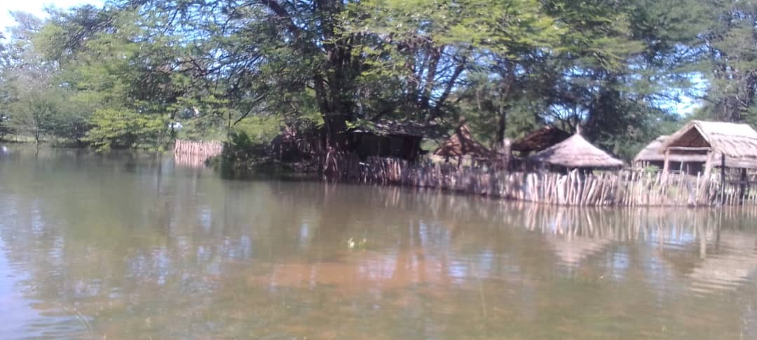
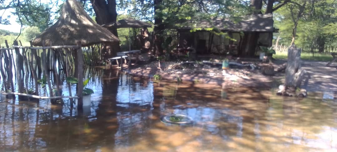
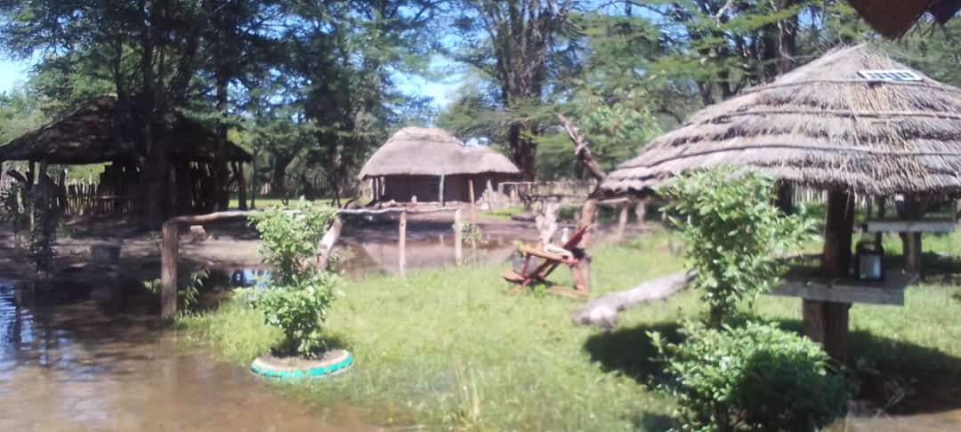
Several villagers in Tsholotsho district were left counting losses as their homesteads and properties were destroyed following excessive rains experienced across the country this past week.

Advertisement

The three day heavy rain spell and destroyed homesteads in Ngamo, Nganyana and Sitambare villages which are situated on the low-lying flat land in the district.

Speaking in an interview with VicfallsLive, one of the victims from Nganyana area, Butholezwe Moyo said his whole homestead was swept away by the storms coupled with winds. 

“My four huts were completely destroyed by the rains,”Moyo said.

Advertisement

“My family and I were left stranded with no roof over our heads. We are not the only ones who we affected, about seven other homesteads in my village lost huts to these rains.

“All our belongings and property were floating on water, the clothes and blankets were soaked in water such that we were unable to use them for sometime until the rains stopped,” he said.

Moyo added that the rains were too much as the floods responded immediately and got to knee level in some parts of Nganyana village.

Advertisement

“We have never experienced the rains of this magnitude in this area. The last time we had something close to this was about 10-15 years ago. This came as a surprise to us.

“As we speak the crops are turning yellow in the fields as they are still half covered with water. Our yields will be affected if the rains continue.”

Another villager from Ngamo, Jerry Mpofu, echoed similar sentiments Moyo about the rains destroying property.

Advertisement

“The rains caused a lot of disruption and destruction in our area. You find a homestead with four or five huts losing them all.

“They are in need of assistance with clothes and blankets,” he said 

In 2017, Tsholotsho district was the most affected area by floods caused by tropical cyclone Dineo that racked havoc across the country.

Advertisement

About 850 people from Mbanyana, Mahlaba, Sheleni, Lutshomi amongst other areas in Tsholotsho district were displaced from their homes in the wake and passage of cyclone Dineo.

The affected families were later resettled in Esawudweni and Ngweba which are on higher ground from their former settlements which were on the low grounds of the river banks.

Meanwhile, the Department of Civil Protection has advised people to take caution against the tropical storm Freddy which is expected to make landfall in the southern parts of Zimbabwe from today. 

Advertisement

Citizens living in low-lying areas were also encouraged to move to higher ground.

The Ministry of Primary and Secondary Education issued a statement urging all institutions providing Primary and Secondary Education to stay alert and keep students safe as there may be flash floods caused by the tropical storm Freddy.

According to the statement, Manicaland, Masvingo, Matebeleland South (parts bordering Masvingo),Mashonaland East ,Mashonaland Central province  and Harare metropolitan province have been placed on high alert and as a result, pupils within the areas are not to attend school or face to face instruction on Friday.

Advertisement


Advertisement
Continue Reading
Click to comment

Leave a Reply

Your email address will not be published. Required fields are marked *

National

Flooding risk rises in Zimbabwe, Southern Africa as heavy rains forecast

Published

on

Flooding is expected to intensify across parts of Southern Africa, including Zimbabwe, as heavy rainfall continues to affect the region, according to the latest weather hazards update from the Famine Early Warning Systems Network (FEWS NET).

In its Global Weather Hazards Summary for March 12–18, FEWS NET said moderate to locally heavy rainfall has been observed across several countries in the region, raising concerns about flooding in vulnerable areas.

Advertisement

The agency said the rainfall has affected western, central and eastern parts of Southern Africa, including Angola, Zambia, Malawi, central Mozambique, northern Madagascar, Botswana, Namibia, South Africa and Zimbabwe.

“During the past week, moderate to locally heavy rainfall was observed over northern, central and eastern Southern Africa,” FEWS NET said in the report.

The agency noted that flooding has already been recorded in some parts of the region, including Cunene Province in southern Angola and Rundu in northern Namibia, as rainfall continued across several countries.

Advertisement

Over the past 30 days, cumulative rainfall has been above average across southeastern Angola, northeastern Botswana, central South Africa, Lesotho, central and southern Zimbabwe and parts of Malawi and Mozambique, increasing the likelihood of flooding in low-lying and flood-prone areas.

FEWS NET warned that the situation could worsen in the coming days.

“(This week) , heavy rainfall is predicted over northern and eastern Zambia, including central and northern Angola, central and eastern Zambia, Malawi, northern and eastern Zimbabwe, Mozambique, northeastern South Africa, Eswatini and northern Madagascar,” the report said.

Advertisement

According to the outlook, the forecast rainfall raises the risk of flooding in many local areas across the region, particularly where soils are already saturated following weeks of above-average rainfall.

The weather monitoring agency also noted that hot conditions are likely in western Angola and southwestern Madagascar, even as other areas brace for continued heavy rains.

FEWS NET provides climate and food security early warning information to support humanitarian planning and disaster preparedness across vulnerable regions.

Advertisement

Continue Reading

National

Parliament debates disputed chiefdoms across the country

Published

on


BY STAFF REPORTER 

Advertisement

Parliament has raised concern over increasing disputes over traditional leadership, with lawmakers warning that contested chiefdoms are undermining governance and development in rural communities.

Moving a motion in the National Assembly, Hwange West MP, Vusumuzi Moyo said the growing number of chieftainship disputes posed a threat to peace and cultural heritage.

“I rise today to debate on a matter which I believe is a matter of national importance, the growing prevalence of disputed chiefdoms across Zimbabwe and the serious threat that these poses to peace, governance, development, and the preservation of our cultural heritage,” Moyo told Parliament. 

Advertisement

He said many disputes date back to distortions created during the colonial period.

“Some of these disputes… emanate from colonial times… when the colonial masters moved in. When they moved in, we already had governing structures,” he said. 

Moyo also referenced communities in Hwange District, saying colonial relocations disrupted traditional governance systems.

Advertisement

“I remember in the constituency that I come from, most of these people… had been resettled from far-off lands, fertile lands, and dumped in Hwange District,” he said. 

He warned that unresolved leadership disputes weaken governance at grassroots level.

“Madam Speaker, when a chiefdom becomes disputed, those constitutional functions grind to a halt. Customary courts lose legitimacy. Land allocations become contested. Development programmes stall,” he said. 

Advertisement

Moyo urged Government to establish clearer succession procedures for traditional leaders.

“It is my sincere hope that… we could start the conversation of trying to restore our culture by providing the necessary legislation to make sure that we cure all this,” he said.  

Advertisement
Continue Reading

National

Rising Zambezi flows lift Kariba water levels amid improved rains

Published

on

BY WANDILE TSHUMA

Water levels at the Kariba Dam are gradually rising following improved rainfall across the Zambezi River Basin, bringing cautious optimism for water availability and power generation.

Advertisement

In a hydrological update released Tuesday, the Zambezi River Authority said the Lake Kariba reservoir level had reached 477.74 metres above sea level as of 10 March 2026.

Usable live storage now stands at 15.57 percent, equivalent to about 10.08 billion cubic metres of usable water.

The Authority said the increase is being driven by improved rainfall across much of the Kariba catchment during the 2025/2026 rainy season, which has boosted river flows and inflows into the reservoir.

Advertisement

“This reflects an improvement compared to the same date in 2025, when the reservoir stood at 476.93 metres above sea level with usable live storage of 9.87 percent,” the Authority said.

Zambezi flows rising at key monitoring points

River flows are also increasing at key monitoring stations along the Zambezi River.

Advertisement

At the Chavuma Gauging Station, flows reached 3,058 cubic metres per second on 10 March 2026, significantly higher than 2,088 cubic metres per second recorded during the same period last year.

Flows have also risen sharply near Victoria Falls, a key tourism and hydrological monitoring point.

At the Victoria Falls (Nana’s Farm) Gauging Station, river flows increased to 1,645 cubic metres per second, compared to 871 cubic metres per second on the same date in 2025.

Advertisement

The Authority said the upward trend reflects stronger rainfall upstream and around the Victoria Falls area, which is feeding the Zambezi system.

Outlook

The Zambezi River Authority said it will continue monitoring rainfall patterns and inflows across the basin to guide water utilisation at hydropower stations linked to the Kariba Dam.

Advertisement

The reservoir is a critical source of electricity for both Zimbabwe and Zambia, which jointly own and manage the dam through the Authority.

Advertisement
Continue Reading

Trending

Copyright © 2022 VicFallsLive. All rights reserved, powered by Advantage