Connect with us

National

Conservationists help tackle poaching in Hwange

Published

on

BY NOKUTHABA DLAMINI

Hwange National Park, once a favourite hunting ground for poachers, has not lost an elephant to the illegal hunters for the past two years largely because of partnerships between the Zimbabwe Parks and Wildlife Management Authority (Zimparks) and non-governmental organisations.

Advertisement

In 2013, over 300 elephants were killed by poachers at the country’s largest game reserve as the menace reached its peak.

Poachers, who included villagers from rural outposts such as Tsholotsho and Hwange used cyanide to kill the elephants for their ivory.

One of the major organisations that have joined hands with Zimparks to protect the animals in Hwange is Bhejani Trust, which also operates at the Zambezi National Park and Kazuma Pan National Park in Matabeleland North.

Advertisement

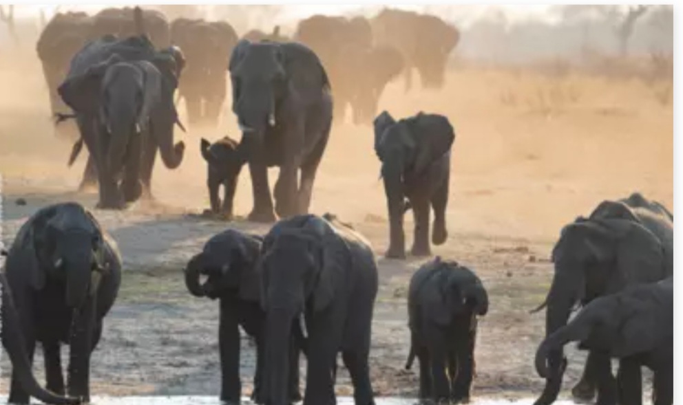
Bhejane Trust director Trevor Lane said the last elephant poaching incident at the Hwange National Park was in 2020 and he attributed the  of the anti-poaching activities to the partnerships between Zimparks and conservation groups.

“Efforts by (Zimparks) and what we do differently to promote conservation in the region has positively impacted on conservation of our wildlife, especially elephants which frequently strayed out of national parks into communal areas to search for food and water,” Lane said.

“As an organisation ours is to ensure that our wildlife has adequate water supply because generally where we operate natural water is drying up fast during the summer and the pressure of elephants all coming together.

Advertisement

“We are faced with a challenge of keeping up with the demand in order for us to keep them inside the parks.

“Every year we have managed to put in a few more water pumps. We are trying to put in more pumps into the back area of Robins Camp because while there’s natural water, there’s a good population of elephants.

“But once that dries up the elephants are all forced to go forward to the existing pumps, which adds to the pressure. Some end up straying outside, leading to human wildlife conflict situations, that’s why we want to add more from the existing 49 to drive them back into the park.”

Advertisement

The organisation pumps one million litres of water per day, which is consumed by approximately 16 000 elephants out of the 44 000 found in the Hwange National Park

Another fruitful partnership for Zimparks is with the international Fund for Animal Welfare (IFAW), which recently set up a new ranger station in the Makona area of Hwange National Park to strengthen the fight against poachers.

IFAW said the ranger station will also help the communities living near the park, who have suffered from elephants and other large herbivores destroying their crops and predators killing their livestock.

Advertisement

“When complete, the camp will be home to 56 rangers and their families who will live and work there,” IFAW said in a statement.

“Comfortable housing, equipped with electricity and running water, is being built for junior rangers and senior staff, and a recreation centre is under construction.

The operations centre is already in use and set up with a landscape-wide VHF radio network—vital communications equipment that connects rangers and improves responses to incidents of poaching.”

Advertisement

IFAW said before the camp was constructed responses to poaching incidents and reaction to reports on problem animals were slow, with rangers being deployed from Hwange Main Camp, some 95 kilometres away and enduring a terrible road snaking through the sticky Kalahari sands.

Augustine Gomba, Zimparks’ wildlife cfficer based at Hwange Main Camp, said before the road was developed, driving to Makona was a nightmare.

“The sandy soils and the rugged nature of the road meant that on average the trip to Makona would take a grueling four hours at least,” Gomba said.

Advertisement

A key achievement of the IFAW-Zimparks agreement was the improvement of the road, cutting a journey that could take up to four hours down to less than two.

The park is nestled on the edge of the Kalahari Desert and is home to some of Africa’s most iconic species.

Being largely flat and dominated by scattered woodlands of teak trees, it was an easy target for poachers.

Advertisement

“The new ranger station will prevent poachers from entering Hwange National Park into the future, allowing the park’s elephants and other wildlife to continue to flourish,” IFAW said.

Zimparks struggles to fund conservation efforts due to poor funding. – The Standard

Advertisement
Continue Reading
Click to comment

Leave a Reply

Your email address will not be published. Required fields are marked *

National

Flooding risk rises in Zimbabwe, Southern Africa as heavy rains forecast

Published

on

Flooding is expected to intensify across parts of Southern Africa, including Zimbabwe, as heavy rainfall continues to affect the region, according to the latest weather hazards update from the Famine Early Warning Systems Network (FEWS NET).

In its Global Weather Hazards Summary for March 12–18, FEWS NET said moderate to locally heavy rainfall has been observed across several countries in the region, raising concerns about flooding in vulnerable areas.

Advertisement

The agency said the rainfall has affected western, central and eastern parts of Southern Africa, including Angola, Zambia, Malawi, central Mozambique, northern Madagascar, Botswana, Namibia, South Africa and Zimbabwe.

“During the past week, moderate to locally heavy rainfall was observed over northern, central and eastern Southern Africa,” FEWS NET said in the report.

The agency noted that flooding has already been recorded in some parts of the region, including Cunene Province in southern Angola and Rundu in northern Namibia, as rainfall continued across several countries.

Advertisement

Over the past 30 days, cumulative rainfall has been above average across southeastern Angola, northeastern Botswana, central South Africa, Lesotho, central and southern Zimbabwe and parts of Malawi and Mozambique, increasing the likelihood of flooding in low-lying and flood-prone areas.

FEWS NET warned that the situation could worsen in the coming days.

“(This week) , heavy rainfall is predicted over northern and eastern Zambia, including central and northern Angola, central and eastern Zambia, Malawi, northern and eastern Zimbabwe, Mozambique, northeastern South Africa, Eswatini and northern Madagascar,” the report said.

Advertisement

According to the outlook, the forecast rainfall raises the risk of flooding in many local areas across the region, particularly where soils are already saturated following weeks of above-average rainfall.

The weather monitoring agency also noted that hot conditions are likely in western Angola and southwestern Madagascar, even as other areas brace for continued heavy rains.

FEWS NET provides climate and food security early warning information to support humanitarian planning and disaster preparedness across vulnerable regions.

Advertisement

Continue Reading

National

Parliament debates disputed chiefdoms across the country

Published

on


BY STAFF REPORTER 

Advertisement

Parliament has raised concern over increasing disputes over traditional leadership, with lawmakers warning that contested chiefdoms are undermining governance and development in rural communities.

Moving a motion in the National Assembly, Hwange West MP, Vusumuzi Moyo said the growing number of chieftainship disputes posed a threat to peace and cultural heritage.

“I rise today to debate on a matter which I believe is a matter of national importance, the growing prevalence of disputed chiefdoms across Zimbabwe and the serious threat that these poses to peace, governance, development, and the preservation of our cultural heritage,” Moyo told Parliament. 

Advertisement

He said many disputes date back to distortions created during the colonial period.

“Some of these disputes… emanate from colonial times… when the colonial masters moved in. When they moved in, we already had governing structures,” he said. 

Moyo also referenced communities in Hwange District, saying colonial relocations disrupted traditional governance systems.

Advertisement

“I remember in the constituency that I come from, most of these people… had been resettled from far-off lands, fertile lands, and dumped in Hwange District,” he said. 

He warned that unresolved leadership disputes weaken governance at grassroots level.

“Madam Speaker, when a chiefdom becomes disputed, those constitutional functions grind to a halt. Customary courts lose legitimacy. Land allocations become contested. Development programmes stall,” he said. 

Advertisement

Moyo urged Government to establish clearer succession procedures for traditional leaders.

“It is my sincere hope that… we could start the conversation of trying to restore our culture by providing the necessary legislation to make sure that we cure all this,” he said.  

Advertisement
Continue Reading

National

Rising Zambezi flows lift Kariba water levels amid improved rains

Published

on

BY WANDILE TSHUMA

Water levels at the Kariba Dam are gradually rising following improved rainfall across the Zambezi River Basin, bringing cautious optimism for water availability and power generation.

Advertisement

In a hydrological update released Tuesday, the Zambezi River Authority said the Lake Kariba reservoir level had reached 477.74 metres above sea level as of 10 March 2026.

Usable live storage now stands at 15.57 percent, equivalent to about 10.08 billion cubic metres of usable water.

The Authority said the increase is being driven by improved rainfall across much of the Kariba catchment during the 2025/2026 rainy season, which has boosted river flows and inflows into the reservoir.

Advertisement

“This reflects an improvement compared to the same date in 2025, when the reservoir stood at 476.93 metres above sea level with usable live storage of 9.87 percent,” the Authority said.

Zambezi flows rising at key monitoring points

River flows are also increasing at key monitoring stations along the Zambezi River.

Advertisement

At the Chavuma Gauging Station, flows reached 3,058 cubic metres per second on 10 March 2026, significantly higher than 2,088 cubic metres per second recorded during the same period last year.

Flows have also risen sharply near Victoria Falls, a key tourism and hydrological monitoring point.

At the Victoria Falls (Nana’s Farm) Gauging Station, river flows increased to 1,645 cubic metres per second, compared to 871 cubic metres per second on the same date in 2025.

Advertisement

The Authority said the upward trend reflects stronger rainfall upstream and around the Victoria Falls area, which is feeding the Zambezi system.

Outlook

The Zambezi River Authority said it will continue monitoring rainfall patterns and inflows across the basin to guide water utilisation at hydropower stations linked to the Kariba Dam.

Advertisement

The reservoir is a critical source of electricity for both Zimbabwe and Zambia, which jointly own and manage the dam through the Authority.

Advertisement
Continue Reading

Trending

Copyright © 2022 VicFallsLive. All rights reserved, powered by Advantage